Geolocate

Mawilmada topographic map

Click on the map to display elevation.

About this map

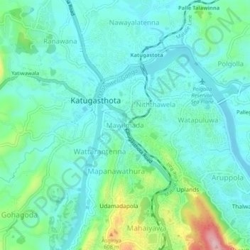
Name: Mawilmada topographic map, elevation, terrain.

Location: Mawilmada, Kandy District, Central Province, 20250, Sri Lanka (7.29812 80.60969 7.33812 80.64969)

Average elevation: 1,572 ft

Minimum elevation: 1,424 ft

Maximum elevation: 2,087 ft

Other topographic maps

Click on a map to view its topography, its elevation and its terrain.

Matale District

Sri Lanka > Central Province

Average elevation: 886 ft

Upper Kotmale Dam

Sri Lanka > Central Province > Talawakele > Holyrood

Average elevation: 4,098 ft

Sigiriya

Sri Lanka > Central Province

Average elevation: 666 ft

Nuwara Eliya District

Sri Lanka > Central Province

Average elevation: 3,586 ft

Pitawala Pathana

Sri Lanka > Central Province

Average elevation: 2,421 ft

Canyon Dam

Sri Lanka > Central Province > Hapugastenne

Average elevation: 3,615 ft

Gear up for your next adventure:

🔭Compact Binoculars - HD vision for scouting terrain and identifying distant landmarks
🪶Fire Starter Kit - Reliable fire starter for survival and camping
📱Solar Portable Charger - Solar power bank for charging devices off‑grid
😴Insulated Sleeping Pads - Compact and warm pads for high-elevation camping
🩹Survival Bandages - High‑quality bandages for emergencies

As an Amazon Associate, this site earns from qualifying purchases at no extra cost to you.