Geolocate

Walker topographic map

Click on the map to display elevation.

About this map

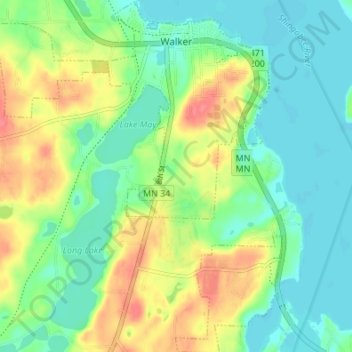
Name: Walker topographic map, elevation, terrain.

Location: Walker, Cass County, Minnesota, United States (47.06078 -94.62004 47.10706 -94.56454)

Average elevation: 1,362 ft

Minimum elevation: 1,286 ft

Maximum elevation: 1,490 ft

Cass County trails, hiking, mountain biking, running and outdoor activities

Other topographic maps

Click on a map to view its topography, its elevation and its terrain.

Pontoria

United States > Minnesota > Cass County

Average elevation: 1,342 ft

Wilkinson

United States > Minnesota > Cass County

Average elevation: 1,306 ft

Gull River

United States > Minnesota > Cass County > East Gull Lake

Average elevation: 1,214 ft

Gear up for your next adventure:

🧭Compass with Lanyard - Easy‑carry compass for navigation
💧Water Filtration Bottles - Safely drink from streams and lakes while exploring
🪑Portable Camp Table - Compact table for campsite meals
🪶Thermal Camp Blanket - Extra warmth for cold nights
🌲Outdoor Survival Books - Best books on survival skills

As an Amazon Associate, this site earns from qualifying purchases at no extra cost to you.