
Make a donation
Gear up for your next adventure:
As an Amazon Associate, this site earns from qualifying purchases at no extra cost to you.
Kissena Park topographic map
Click on the map to display elevation.
Make a donation
Gear up for your next adventure:
As an Amazon Associate, this site earns from qualifying purchases at no extra cost to you.
Kissena Park
Kissena Park's natural features were formed during the Wisconsin glaciation, about 20,000 years ago. The site of Flushing Meadows–Corona Park, slightly west of Kissena Park, was originally part of the ancestral path of the Hudson River, and the present-day Kissena Lake was located on the eastern shore of the river. The glacier covered much of Long Island, where Queens is located, and formed a terminal moraine through the center of the island. One of these recesses became Kissena Lake. When the glacier receded, it created several recesses in the land, some of which were filled with water. The topography of Flushing and Northeast Queens was formed during this time, including the creation of Kissena Lake. Glaciation also created a natural source of well water for the area.
Make a donation
Gear up for your next adventure:
As an Amazon Associate, this site earns from qualifying purchases at no extra cost to you.
About this map
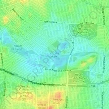
Name: Kissena Park topographic map, elevation, terrain.
Location: Kissena Park, Queens County, New York, United States (40.74207 -73.81415 40.75003 -73.80290)
Average elevation: 52 ft
Minimum elevation: 3 ft
Maximum elevation: 135 ft
New York trails, hiking, mountain biking, running and outdoor activities
Make a donation
Gear up for your next adventure:
As an Amazon Associate, this site earns from qualifying purchases at no extra cost to you.
Other topographic maps
Click on a map to view its topography, its elevation and its terrain.
Manhattan Island
United States > New York > New York
Marble Hill is one example of how Manhattan's land has been considerably altered by human intervention. The borough has seen substantial land reclamation along its waterfronts since Dutch colonial times, and much of the natural variation in its topography has been evened out.
Average elevation: 56 ft
Washington Heights
United States > New York > New York
Because of their abrupt, hilly topography, pedestrian navigation in Upper Manhattan is facilitated by many step streets. The longest of these in Washington Heights, at approximately 130 stairs and with an elevation gain of approximately 65 feet, connects Fort Washington Avenue and Overlook Terrace at 187th…
Average elevation: 82 ft
Make a donation
Gear up for your next adventure:
As an Amazon Associate, this site earns from qualifying purchases at no extra cost to you.
Make a donation
Gear up for your next adventure:
As an Amazon Associate, this site earns from qualifying purchases at no extra cost to you.