
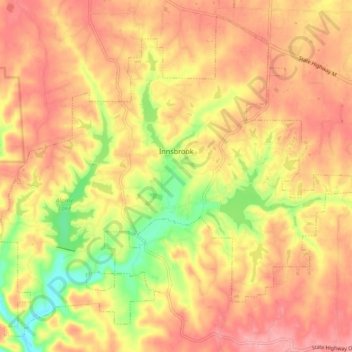
Innsbrook topographic map
Click on the map to display elevation.
About this map
Name: Innsbrook topographic map, elevation, terrain.
Location: Innsbrook, Warren County, Missouri, United States (38.73132 -91.09815 38.79685 -91.00590)
Average elevation: 761 ft
Minimum elevation: 545 ft
Maximum elevation: 892 ft
Other topographic maps
Click on a map to view its topography, its elevation and its terrain.
Little Lost Creek Conservation Area
United States > Missouri > Warren County > Pendleton
Average elevation: 791 ft