
Thank you for supporting this site ❤️
Make a donation
Make a donation
Gear up for your next adventure:
As an Amazon Associate, this site earns from qualifying purchases at no extra cost to you.
Fatehpur Shekhawati topographic map
Click on the map to display elevation.
Thank you for supporting this site ❤️
Make a donation
Make a donation
Gear up for your next adventure:
As an Amazon Associate, this site earns from qualifying purchases at no extra cost to you.
Fatehpur Shekhawati
Fatehpur is located at 27°59′N 74°57′E / 27.98°N 74.95°E / 27.98; 74.95. It has an average elevation of 324 metres (1066 ft). It is home to very rare Jojoba farm.
Thank you for supporting this site ❤️
Make a donation
Make a donation
Gear up for your next adventure:
As an Amazon Associate, this site earns from qualifying purchases at no extra cost to you.
About this map
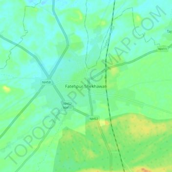
Name: Fatehpur Shekhawati topographic map, elevation, terrain.
Average elevation: 1,073 ft
Minimum elevation: 1,040 ft
Maximum elevation: 1,152 ft
Thank you for supporting this site ❤️
Make a donation
Make a donation
Gear up for your next adventure:
As an Amazon Associate, this site earns from qualifying purchases at no extra cost to you.