
Thank you for supporting this site ❤️
Make a donation
Make a donation
Gear up for your next adventure:
As an Amazon Associate, this site earns from qualifying purchases at no extra cost to you.
Tsiu Keng topographic map
Click on the map to display elevation.
Thank you for supporting this site ❤️
Make a donation
Make a donation
Gear up for your next adventure:
As an Amazon Associate, this site earns from qualifying purchases at no extra cost to you.
About this map
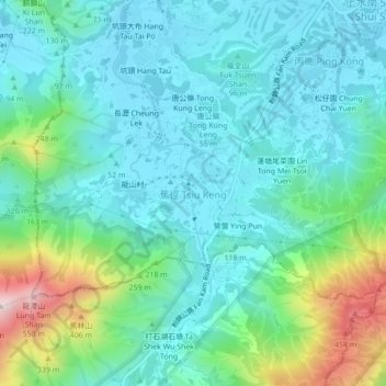
Name: Tsiu Keng topographic map, elevation, terrain.
Location: Tsiu Keng, North District, New Territories, Hong Kong, China (22.45662 114.08713 22.49662 114.12713)
Average elevation: 427 ft
Minimum elevation: 16 ft
Maximum elevation: 1,877 ft
Thank you for supporting this site ❤️
Make a donation
Make a donation
Gear up for your next adventure:
As an Amazon Associate, this site earns from qualifying purchases at no extra cost to you.