
Thank you for supporting this site ❤️
Make a donation
Make a donation
Gear up for your next adventure:
As an Amazon Associate, this site earns from qualifying purchases at no extra cost to you.
Camorritos topographic map
Click on the map to display elevation.
Thank you for supporting this site ❤️
Make a donation
Make a donation
Gear up for your next adventure:
As an Amazon Associate, this site earns from qualifying purchases at no extra cost to you.
About this map
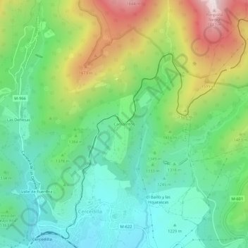
Name: Camorritos topographic map, elevation, terrain.
Location: Camorritos, Cercedilla, Comunidad de Madrid, 28491, España (40.73539 -4.06853 40.77539 -4.02853)
Average elevation: 4,547 ft
Minimum elevation: 3,711 ft
Maximum elevation: 6,207 ft
Thank you for supporting this site ❤️
Make a donation
Make a donation
Gear up for your next adventure:
As an Amazon Associate, this site earns from qualifying purchases at no extra cost to you.