
Make a donation
Gear up for your next adventure:
As an Amazon Associate, this site earns from qualifying purchases at no extra cost to you.
Monte Verde topographic map
Click on the map to display elevation.
Make a donation
Gear up for your next adventure:
As an Amazon Associate, this site earns from qualifying purchases at no extra cost to you.
About this map
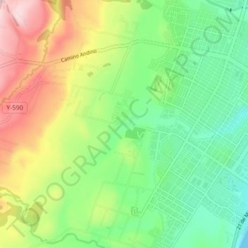
Name: Monte Verde topographic map, elevation, terrain.
Average elevation: 335 ft
Minimum elevation: 0 ft
Maximum elevation: 883 ft
Make a donation
Gear up for your next adventure:
As an Amazon Associate, this site earns from qualifying purchases at no extra cost to you.
Other topographic maps
Click on a map to view its topography, its elevation and its terrain.
Isla Noir
Chile > Región de Magallanes y de la Antártica Chilena > Provincia de Magallanes > Punta Arenas
Average elevation: 102 ft
Faro San Isidro
Chile > Región de Magallanes y de la Antártica Chilena > Provincia de Magallanes > Punta Arenas
Average elevation: 92 ft
Islas Charles
Chile > Región de Magallanes y de la Antártica Chilena > Provincia de Magallanes > Punta Arenas
Average elevation: 66 ft
Isla del Medio
Chile > Región de Magallanes y de la Antártica Chilena > Provincia de Magallanes > Punta Arenas
Average elevation: 72 ft
Make a donation
Gear up for your next adventure:
As an Amazon Associate, this site earns from qualifying purchases at no extra cost to you.
Plaza las Campanitas
Chile > Región de Magallanes y de la Antártica Chilena > Provincia de Magallanes > Punta Arenas
Average elevation: 180 ft