Geolocate

Altmannstein topographic map

Click on the map to display elevation.

About this map

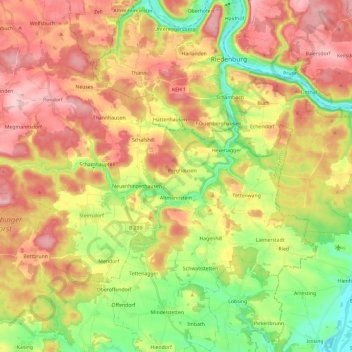
Name: Altmannstein topographic map, elevation, terrain.

Location: Altmannstein, Landkreis Eichstätt, Bavaria, 93336, Germany (48.85780 11.50798 48.96106 11.74421)

Average elevation: 1,460 ft

Minimum elevation: 1,125 ft

Maximum elevation: 1,798 ft

Other topographic maps

Click on a map to view its topography, its elevation and its terrain.

Schamhaupten

Germany > Bavaria > Landkreis Eichstätt

Average elevation: 1,509 ft

Gungolding

Germany > Bavaria > Landkreis Eichstätt

Average elevation: 1,447 ft

Preith

Germany > Bavaria > Landkreis Eichstätt

Average elevation: 1,742 ft

Gear up for your next adventure:

🔦LED Headlamp - Bright and durable LED headlamp for night navigation
🥾Men's Hiking Boots - Durable, waterproof footwear for rugged terrain and steep inclines
🥾Hiking Shoes - Durable and comfortable shoes for trail hiking
🎒Trekking Poles - Sturdy poles for balance and stability on rough terrain
🚑Emergency Bivvies - Heat-reflective sleeping bags for survival situations

As an Amazon Associate, this site earns from qualifying purchases at no extra cost to you.