Geolocate

Metera topographic map

Click on the map to display elevation.

About this map

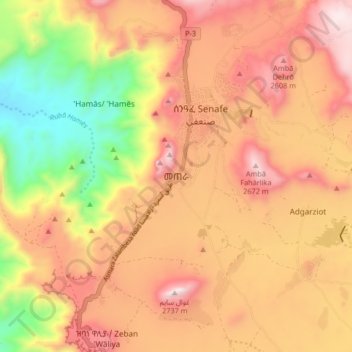
Name: Metera topographic map, elevation, terrain.

Location: Metera, Debub Region, Eritrea (14.64768 39.37863 14.72768 39.45863)

Average elevation: 7,651 ft

Minimum elevation: 6,014 ft

Maximum elevation: 8,891 ft

Other topographic maps

Click on a map to view its topography, its elevation and its terrain.

Adi halo

Eritrea > Debub Region

Average elevation: 6,417 ft

Mereb river

Eritrea > Debub Region

Average elevation: 4,646 ft

Mereb river ሩባ መረብ

Eritrea > Debub Region

Average elevation: 4,774 ft

Ma'ereba

Eritrea > Debub Region

Average elevation: 6,890 ft

Mereb river

Eritrea > Debub Region

Average elevation: 4,892 ft

Gear up for your next adventure:

🔭Telescopic Hiking Pole - Adjustable pole for hiking stability
🧭Outdoor Navigation Book - Learn advanced navigation skills
📦Gear Storage Bags - Organize and protect outdoor equipment
☀️Outdoor Sunscreen - High protection sunscreen for outdoor activities
🪶Thermal Camp Blanket - Extra warmth for cold nights

As an Amazon Associate, this site earns from qualifying purchases at no extra cost to you.