
Make a donation
Gear up for your next adventure:
As an Amazon Associate, this site earns from qualifying purchases at no extra cost to you.
Hakone topographic map
Click on the map to display elevation.
Make a donation
Gear up for your next adventure:
As an Amazon Associate, this site earns from qualifying purchases at no extra cost to you.
Hakone
Hakone is characterized by its rugged topography, featuring a mix of mountainous terrain, valleys, and volcanic landscapes. Nestled within the greater Fuji-Hakone-Izu National Park, Hakone's elevation varies dramatically, with peaks rising over 4,000 feet and low-lying areas near Lake Ashi, which sits at approximately 2,400 feet above sea level. The area is shaped by its volcanic origin, leading to numerous hot springs and a rich variety of flora and fauna, especially in the dense alpine forests and marshy wetlands. The combination of steep hills and valleys creates stunning vistas, particularly from vantage points like the Hakone Ropeway, which offers panoramic views of the surrounding landscape, including Mount Fuji. Overall, the diverse topography of Hakone makes it a prime location for outdoor activities, tourism, and nature observation.
Make a donation
Gear up for your next adventure:
As an Amazon Associate, this site earns from qualifying purchases at no extra cost to you.
About this map
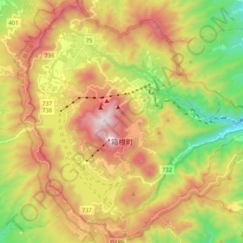
Name: Hakone topographic map, elevation, terrain.
Average elevation: 2,369 ft
Minimum elevation: 344 ft
Maximum elevation: 4,633 ft
Make a donation
Gear up for your next adventure:
As an Amazon Associate, this site earns from qualifying purchases at no extra cost to you.