
Thank you for supporting this site ❤️
Make a donation
Make a donation
Gear up for your next adventure:
As an Amazon Associate, this site earns from qualifying purchases at no extra cost to you.
Steglitz topographic map
Click on the map to display elevation.
Thank you for supporting this site ❤️
Make a donation
Make a donation
Gear up for your next adventure:
As an Amazon Associate, this site earns from qualifying purchases at no extra cost to you.
About this map
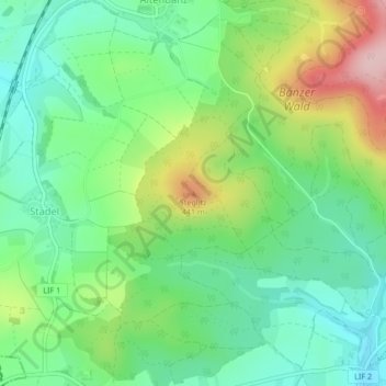
Name: Steglitz topographic map, elevation, terrain.
Average elevation: 1,125 ft
Minimum elevation: 892 ft
Maximum elevation: 1,575 ft
Thank you for supporting this site ❤️
Make a donation
Make a donation
Gear up for your next adventure:
As an Amazon Associate, this site earns from qualifying purchases at no extra cost to you.
Other topographic maps
Click on a map to view its topography, its elevation and its terrain.
https://www.regierung.oberfranken.bayern.de/nsg/5-35/5-35-02-Verordnung.pdf
Deutschland > Bayern > Landkreis Lichtenfels > Bad Staffelstein > Romansthal
Average elevation: 1,181 ft
Trimeusel
Deutschland > Bayern > Landkreis Lichtenfels > Bad Staffelstein > Nedensdorf
Average elevation: 945 ft