
Make a donation
Gear up for your next adventure:
As an Amazon Associate, this site earns from qualifying purchases at no extra cost to you.
Wentworth topographic map
Click on the map to display elevation.
Make a donation
Gear up for your next adventure:
As an Amazon Associate, this site earns from qualifying purchases at no extra cost to you.
About this map
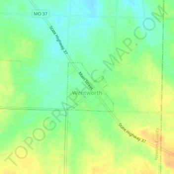
Name: Wentworth topographic map, elevation, terrain.
Location: Wentworth, Newton County, Missouri, United States (36.99003 -94.07925 36.99762 -94.07020)
Average elevation: 1,237 ft
Minimum elevation: 1,188 ft
Maximum elevation: 1,289 ft
Newton County trails, hiking, mountain biking, running and outdoor activities
Make a donation
Gear up for your next adventure:
As an Amazon Associate, this site earns from qualifying purchases at no extra cost to you.
Other topographic maps
Click on a map to view its topography, its elevation and its terrain.
Shoal Creek
United States > Missouri > Newton County > Joplin > Cliff Village
Average elevation: 968 ft
Make a donation
Gear up for your next adventure:
As an Amazon Associate, this site earns from qualifying purchases at no extra cost to you.