Geolocate

San Isabel topographic map

Click on the map to display elevation.

About this map

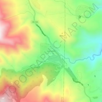
Name: San Isabel topographic map, elevation, terrain.

Location: San Isabel, Custer County, Colorado, United States (37.96751 -105.07444 38.00751 -105.03444)

Average elevation: 8,970 ft

Minimum elevation: 7,871 ft

Maximum elevation: 10,312 ft

Custer County trails, hiking, mountain biking, running and outdoor activities

Other topographic maps

Click on a map to view its topography, its elevation and its terrain.

Silver Cliff

United States > Colorado > Custer County

Average elevation: 8,225 ft

Westcliffe

United States > Colorado > Custer County

Average elevation: 7,887 ft

Westcliffe

United States > Colorado > Custer County

Average elevation: 7,887 ft

Gear up for your next adventure:

🪶Survival Guide Book - Expert advice for emergency preparedness
🕶️Glacier Sunglasses - Side shields to protect eyes from high-altitude snow glare
📦Dry Bags Set - Waterproof storage for electronics and clothes
🧣Hiking Neck Gaiter - Multi‑use neck protection for outdoor weather
🚁Photography Drones - Capture stunning aerial views of landforms and topography

As an Amazon Associate, this site earns from qualifying purchases at no extra cost to you.