
Make a donation
Gear up for your next adventure:
As an Amazon Associate, this site earns from qualifying purchases at no extra cost to you.
Konawe topographic map
Click on the map to display elevation.
Make a donation
Gear up for your next adventure:
As an Amazon Associate, this site earns from qualifying purchases at no extra cost to you.
About this map
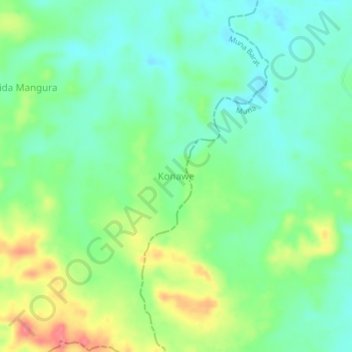
Name: Konawe topographic map, elevation, terrain.
Location: Konawe, Southeast Sulawesi, Indonesia (-4.74538 122.61377 -4.70538 122.65377)
Average elevation: 184 ft
Minimum elevation: 95 ft
Maximum elevation: 348 ft
Make a donation
Gear up for your next adventure:
As an Amazon Associate, this site earns from qualifying purchases at no extra cost to you.
Other topographic maps
Click on a map to view its topography, its elevation and its terrain.
Wakatobi National Park
Indonesia > Southeast Sulawesi
It consists of four larger islands: Wangi-Wangi, Kaledupa, Tomia and Binongko, as well as many small islands such as Tokobao, North Lintea, South Lintea, Kampenaune, Hoga and Tolandono. The highest elevation is 274 metres (899 ft) on Wangi-Wangi, followed by Lagole Hill (271m) on Tomia, Terpadu Hill (222 m) on…
Average elevation: 3 ft
Kendari
Indonesia > Southeast Sulawesi
Kendari borders the Konawe Regency in the north, South Konawe Regency in the south and west, and Kendari Bay in the east. The city is on the southeastern part of mainland Sulawesi island; several smaller islands around the bay are within its boundaries. The city's topography varies from flat to hilly. Coastal…
Average elevation: 220 ft
Make a donation
Gear up for your next adventure:
As an Amazon Associate, this site earns from qualifying purchases at no extra cost to you.
Make a donation
Gear up for your next adventure:
As an Amazon Associate, this site earns from qualifying purchases at no extra cost to you.
Make a donation
Gear up for your next adventure:
As an Amazon Associate, this site earns from qualifying purchases at no extra cost to you.
Make a donation
Gear up for your next adventure:
As an Amazon Associate, this site earns from qualifying purchases at no extra cost to you.
Make a donation
Gear up for your next adventure:
As an Amazon Associate, this site earns from qualifying purchases at no extra cost to you.
Make a donation
Gear up for your next adventure:
As an Amazon Associate, this site earns from qualifying purchases at no extra cost to you.
Make a donation
Gear up for your next adventure:
As an Amazon Associate, this site earns from qualifying purchases at no extra cost to you.