
Make a donation
Gear up for your next adventure:
As an Amazon Associate, this site earns from qualifying purchases at no extra cost to you.
Moosburg topographic map
Click on the map to display elevation.
Make a donation
Gear up for your next adventure:
As an Amazon Associate, this site earns from qualifying purchases at no extra cost to you.
Moosburg
The oldest town between Regensburg and Italy lies on the river Isar at an altitude of 421 m (1381 ft). It has 20,237 inhabitants (2022) and covers an area of 44 km2. It is easily reached by the A 92 autobahn and regional trains on the Munich–Regensburg line. Furthermore, it takes just 20 minutes to get to Munich Airport.
Make a donation
Gear up for your next adventure:
As an Amazon Associate, this site earns from qualifying purchases at no extra cost to you.
About this map
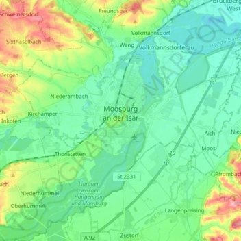
Name: Moosburg topographic map, elevation, terrain.
Location: Moosburg, Landkreis Freising, Bavaria, 85368, Germany (48.42698 11.86724 48.49993 12.01942)
Average elevation: 1,404 ft
Minimum elevation: 1,302 ft
Maximum elevation: 1,683 ft
Make a donation
Gear up for your next adventure:
As an Amazon Associate, this site earns from qualifying purchases at no extra cost to you.
Other topographic maps
Click on a map to view its topography, its elevation and its terrain.
Make a donation
Gear up for your next adventure:
As an Amazon Associate, this site earns from qualifying purchases at no extra cost to you.