
Günzenhausen topographic map
Interactive map
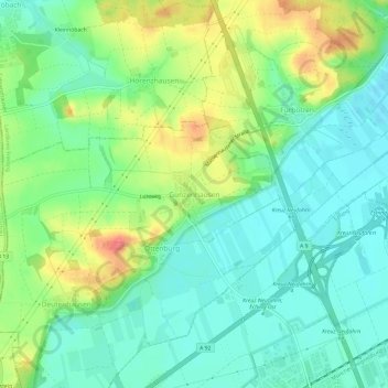
Click on the map to display elevation.
About this map
Name: Günzenhausen topographic map, elevation, terrain.
Average elevation: 1,565 ft
Minimum elevation: 1,490 ft
Maximum elevation: 1,709 ft
Other topographic maps
Click on a map to view its topography, its elevation and its terrain.
Moosburg
Germany > Bavaria > Landkreis Freising
The oldest town between Regensburg and Italy, it lies on the river Isar at an altitude of 421 m (1381 ft). It has 20,237 inhabitants (2022) and covers an area of 44 km2. It is easily reached by the A 92 autobahn and regional trains on the Munich–Regensburg line. Furthermore, it takes just 20 minutes to get…
Average elevation: 1,404 ft
85413
Germany > Bavaria > Landkreis Freising > Margarethenried > Sixt in der Point
Average elevation: 1,588 ft
Freising
Germany > Bavaria > Landkreis Freising
In 1802/1803 Bavaria fell under the influence of Napoleonic France in which church controlled lands were secularized. In Freising, the more than thousand-year-old bishopric was abolished. The Roman Catholic Church lost most of its properties and authority over the city. Though the seat of the diocese was moved…
Average elevation: 1,499 ft
Moosburg
Germany > Bavaria > Landkreis Freising
The oldest town between Regensburg and Italy, it lies on the river Isar at an altitude of 421 m (1381 ft). It has 20,237 inhabitants (2022) and covers an area of 44 km2. It is easily reached by the A 92 autobahn and regional trains on the Munich–Regensburg line. Furthermore, it takes just 20 minutes to get…
Average elevation: 1,404 ft