
Lakeview topographic map
Click on the map to display elevation.
Lakeview
Lakeview is a city in Lake County, Oregon, United States. The population was 2,418 at the 2020 census. It is the county seat of Lake County. The city bills itself as the "Tallest Town in Oregon" because of its elevation, 4,757 feet (1,450 m) above sea level. Lakeview is situated in the Goose Lake Valley at the foot of the Warner Mountains and at the edge of Oregon's high desert country. Its economy is based on agriculture, lumber production, and government activities. In addition, tourism is an increasingly important part of the city's economy. Oregon's Outback Scenic Byway passes through Lakeview.
About this map
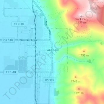
Name: Lakeview topographic map, elevation, terrain.
Location: Lakeview, Lake County, Oregon, 97630, United States (42.16423 -120.37558 42.21158 -120.33630)
Average elevation: 5,125 ft
Minimum elevation: 4,724 ft
Maximum elevation: 6,430 ft
Lake County trails, hiking, mountain biking, running and outdoor activities
Other topographic maps
Click on a map to view its topography, its elevation and its terrain.
Hager Mountain
United States > Oregon > Lake County
Hager Mountain is located on the edge of Oregon's high desert in the northwest corner of the Basin and Range Province of the western United States. The mountain is in Lake County, approximately 10 miles (16 km) south of the small unincorporated community of Silver Lake. The summit of Hager Mountain is at 7,189…
Average elevation: 6,175 ft
Valley Falls
United States > Oregon > Lake County
In 1832, John Work led his Hudson's Bay Company trapping brigade through the Valley Falls area. Work recorded the visit in his journal. In 1843, Captain John C. Fremont explored the area around Valley Falls. Fremont name Abert Rim and nearby Abert Lake after the head of the United States Army's topographical…
Average elevation: 4,344 ft