
Thank you for supporting this site ❤️
Make a donation
Make a donation
Gear up for your next adventure:
As an Amazon Associate, this site earns from qualifying purchases at no extra cost to you.
Tannheim Mountains topographic map
Click on the map to display elevation.
Thank you for supporting this site ❤️
Make a donation
Make a donation
Gear up for your next adventure:
As an Amazon Associate, this site earns from qualifying purchases at no extra cost to you.
About this map
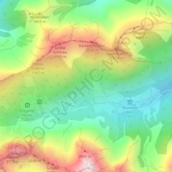
Name: Tannheim Mountains topographic map, elevation, terrain.
Location: Tannheim Mountains, Musau, Bezirk Reutte, Tyrol, 6672, Austria (47.51175 10.62947 47.51185 10.62957)
Average elevation: 5,400 ft
Minimum elevation: 4,127 ft
Maximum elevation: 7,287 ft
Thank you for supporting this site ❤️
Make a donation
Make a donation
Gear up for your next adventure:
As an Amazon Associate, this site earns from qualifying purchases at no extra cost to you.