
Riohacha topographic map
Interactive map
Click on the map to display elevation.
About this map
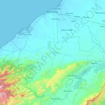
Name: Riohacha topographic map, elevation, terrain.
Location: Riohacha, La Guajira, RAP Caribe, Colombia (10.91072 -73.38560 11.56144 -72.60255)
Average elevation: 873 ft
Minimum elevation: -13 ft
Maximum elevation: 9,843 ft
Other topographic maps
Click on a map to view its topography, its elevation and its terrain.
Riohacha
Colombia > La Guajira > Riohacha
Riohacha, La Guajira, 44001, Colombia
Average elevation: 30 ft