Geolocate

Moss topographic map

Click on the map to display elevation.

About this map

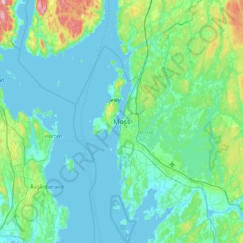
Name: Moss topographic map, elevation, terrain.

Location: Moss, Østfold, 1531, Norway (59.27480 10.50198 59.59480 10.82198)

Average elevation: 138 ft

Minimum elevation: -7 ft

Maximum elevation: 1,073 ft

Other topographic maps

Click on a map to view its topography, its elevation and its terrain.

Ullerøy leirskole

Norway > Østfold > Ullerøy

Average elevation: 46 ft

Kinnekulle

Norway > Østfold

Average elevation: 486 ft

Skiptvet

Norway > Østfold

Average elevation: 381 ft

Moss

Norway > Østfold

Average elevation: 75 ft

Ertevannet

Norway > Østfold

Average elevation: 404 ft

Knivsøya

Norway > Østfold > Isebakke

Average elevation: 112 ft

Halden

Norway > Østfold

Average elevation: 410 ft

Moss

Norway > Østfold

Average elevation: 75 ft

Fredrikstad

Norway > Østfold

Average elevation: 49 ft

Gear up for your next adventure:

💧Water Purification System - Clean water on the trail with reliable purifiers
🩹Survival Bandages - High‑quality bandages for emergencies
🪶Fire Starter Kit - Reliable fire starter for survival and camping
🧦Hiking Socks - Comfortable socks to prevent blisters on long hikes
👖Convertible Hiking Pants - Versatile zip-off pants for changing altitudes and temperatures

As an Amazon Associate, this site earns from qualifying purchases at no extra cost to you.