
Make a donation
Gear up for your next adventure:
As an Amazon Associate, this site earns from qualifying purchases at no extra cost to you.
Le Bleymard topographic map
Click on the map to display elevation.
Make a donation
Gear up for your next adventure:
As an Amazon Associate, this site earns from qualifying purchases at no extra cost to you.
About this map
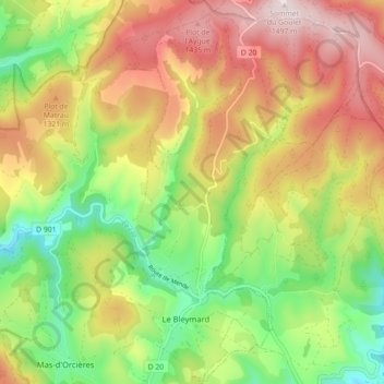
Name: Le Bleymard topographic map, elevation, terrain.
Average elevation: 3,993 ft
Minimum elevation: 3,189 ft
Maximum elevation: 4,898 ft
Make a donation
Gear up for your next adventure:
As an Amazon Associate, this site earns from qualifying purchases at no extra cost to you.
Other topographic maps
Click on a map to view its topography, its elevation and its terrain.
Make a donation
Gear up for your next adventure:
As an Amazon Associate, this site earns from qualifying purchases at no extra cost to you.
Saint-Jean-du-Bleymard
France > Occitanie > Lozère > Mont Lozère et Goulet
Average elevation: 3,780 ft
Make a donation
Gear up for your next adventure:
As an Amazon Associate, this site earns from qualifying purchases at no extra cost to you.
Ruisseau de Coufoulens
France > Occitanie > Lozère > Mont Lozère et Goulet > Saint-Frézal-d'Albuges > La Peyre
Average elevation: 3,986 ft
Make a donation
Gear up for your next adventure:
As an Amazon Associate, this site earns from qualifying purchases at no extra cost to you.