Geolocate

Temban topographic map

Click on the map to display elevation.

About this map

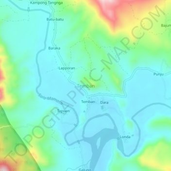
Name: Temban topographic map, elevation, terrain.

Location: Temban, Enrekang, South Sulawesi, Sulawesi, Indonesia (-3.51474 119.70827 -3.47474 119.74827)

Average elevation: 423 ft

Minimum elevation: 194 ft

Maximum elevation: 1,220 ft

Other topographic maps

Click on a map to view its topography, its elevation and its terrain.

Baraka

Indonesia > South Sulawesi > Enrekang

Average elevation: 2,713 ft

Bungin

Indonesia > South Sulawesi > Enrekang

Average elevation: 4,062 ft

Malua

Indonesia > South Sulawesi > Enrekang

Average elevation: 2,326 ft

Buntu Batu

Indonesia > South Sulawesi > Enrekang

Average elevation: 4,787 ft

Cendana

Indonesia > South Sulawesi > Enrekang

Average elevation: 499 ft

Maiwa

Indonesia > South Sulawesi > Enrekang

Average elevation: 702 ft

Malua

Indonesia > South Sulawesi > Enrekang

Average elevation: 2,326 ft

Alla

Indonesia > South Sulawesi > Enrekang

Average elevation: 3,402 ft

Gear up for your next adventure:

🔭Stargazing Telescopes - Perfect for camping in low-light pollution areas shown on maps
GPS Sports Watch - GPS watch for running, hiking and training
⛑️Personal Locator Beacon - Safety beacon for emergencies
🦶Hiking Gaiters - Keep debris and water out of your boots
🧭GPS Watch Accessories - Bands and chargers for GPS watches

As an Amazon Associate, this site earns from qualifying purchases at no extra cost to you.