
Limpopo River topographic map
Interactive map
Click on the map to display elevation.
About this map
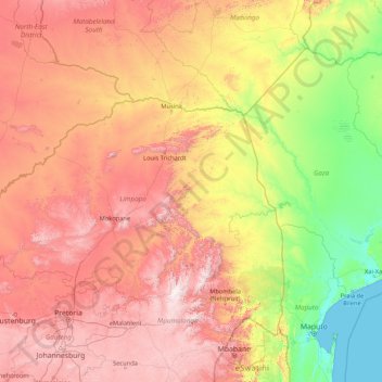
Name: Limpopo River topographic map, elevation, terrain.
Location: Limpopo River, Beitbridge, Matabeleland South, Zimbabwe (-25.20477 26.86030 -22.12423 33.66841)
Average elevation: 2,346 ft
Minimum elevation: -3 ft
Maximum elevation: 7,539 ft
Other topographic maps
Click on a map to view its topography, its elevation and its terrain.
Upper Ncema Dam
Upper Ncema Dam, Umzingwane, Matabeleland South, Zimbabwe
Average elevation: 3,786 ft
Matobo National Park
Matobo National Park, Matobo, Matabeleland South, Zimbabwe
Average elevation: 4,367 ft
Mzingwane
Mzingwane, Gwanda, Matabeleland South, Zimbabwe
Average elevation: 2,694 ft