Geolocate

Mary topographic map

Click on the map to display elevation.

About this map

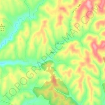
Name: Mary topographic map, elevation, terrain.

Location: Mary, Wolfe County, Kentucky, 41301, United States (37.64842 -83.55630 37.68842 -83.51630)

Average elevation: 981 ft

Minimum elevation: 738 ft

Maximum elevation: 1,234 ft

Wolfe County trails, hiking, mountain biking, running and outdoor activities

Other topographic maps

Click on a map to view its topography, its elevation and its terrain.

Campton

United States > Kentucky > Wolfe County

Average elevation: 1,060 ft

Campton

United States > Kentucky > Wolfe County

Average elevation: 1,060 ft

Campton

United States > Kentucky > Wolfe County

Average elevation: 1,060 ft

Gear up for your next adventure:

🏕️Tent Footprint - Protect your tent base from wear
🛰️Satellite Messengers - Emergency SOS and two-way messaging for off-grid adventures
🧦Hiking Socks - Comfortable socks to prevent blisters on long hikes
📖Nature Tracking Books - Learn to track wildlife and terrain
🪶Compact Camp Shovel - Folding shovel for campsite tasks

As an Amazon Associate, this site earns from qualifying purchases at no extra cost to you.