
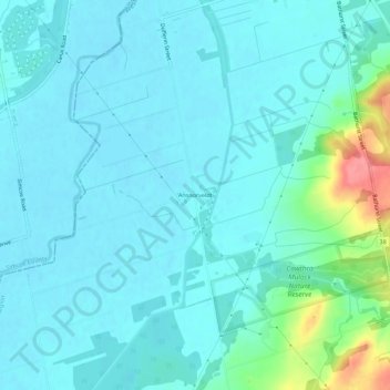
Ansnorveldt topographic map
Interactive map
Click on the map to display elevation.
About this map
Name: Ansnorveldt topographic map, elevation, terrain.
Average elevation: 751 ft
Minimum elevation: 705 ft
Maximum elevation: 984 ft
Other topographic maps
Click on a map to view its topography, its elevation and its terrain.
King City
Canada > Ontario > York Region > King
King City, King, York Region, Golden Horseshoe, Ontario, L7B 1A2, Canada
Average elevation: 991 ft
Glenville
Canada > Ontario > York Region > King
Glenville, King, East Gwillimbury, York Region, Golden Horseshoe, Ontario, L3Y 4V9, Canada
Average elevation: 915 ft
Bell's Lake
Canada > Ontario > York Region > King
Bell's Lake, King, York Region, Golden Horseshoe, Ontario, Canada
Average elevation: 968 ft
Schomberg
Canada > Ontario > York Region > King
Schomberg, King, York Region, Golden Horseshoe, Ontario, L0G 1T0, Canada
Average elevation: 797 ft
Nobleton
Canada > Ontario > York Region > King
Nobleton, King, York Region, Golden Horseshoe, Ontario, L0G 1N0, Canada
Average elevation: 866 ft
King—Vaughan
Canada > Ontario > York Region > King
King—Vaughan, King, East Gwillimbury, York Region, Golden Horseshoe, Ontario, Canada
Average elevation: 869 ft