Geolocate

Jackson topographic map

Click on the map to display elevation.

About this map

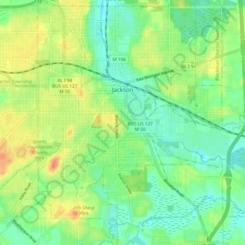
Name: Jackson topographic map, elevation, terrain.

Location: Jackson, Jackson County, Michigan, United States (42.20368 -84.43456 42.27087 -84.35663)

Average elevation: 971 ft

Minimum elevation: 912 ft

Maximum elevation: 1,056 ft

Jackson County trails, hiking, mountain biking, running and outdoor activities

Other topographic maps

Click on a map to view its topography, its elevation and its terrain.

Liberty

United States > Michigan > Jackson County

Average elevation: 1,024 ft

White Lake

United States > Michigan > Jackson County

Average elevation: 945 ft

Sherman Lake

United States > Michigan > Jackson County

Average elevation: 968 ft

Gear up for your next adventure:

🌡️Portable Weather Meter - Track weather conditions on the trail
🧯Portable Fire Pit - Compact fire pit for camping spots
🔊Portable Camp Speaker - Music and alerts at camp
🌧️Backpack Rain Cover - Keep gear dry in wet weather
🥩Freeze-Dried Meals - Nutritious and lightweight food for remote expeditions

As an Amazon Associate, this site earns from qualifying purchases at no extra cost to you.