
Make a donation
Gear up for your next adventure:
As an Amazon Associate, this site earns from qualifying purchases at no extra cost to you.
Iserlohn topographic map
Click on the map to display elevation.
Make a donation
Gear up for your next adventure:
As an Amazon Associate, this site earns from qualifying purchases at no extra cost to you.
Iserlohn
Das Stadtgebiet wird im Westen auf einer Länge von 7,2 km von der Lenne durchquert und von der Ruhr im Norden zum Kreis Unna hin begrenzt, die eine Länge von 7,5 km im Stadtgebiet aufweist. Wichtige Bäche sind der Grüner Bach, der in die Lenne fließt, und der Baarbach, der im Norden in die Ruhr mündet. Der Baarbach ist samt Quellbach 18 km lang und damit das längste Gewässer in Iserlohn. Das Kernstadtgebiet und die Gebiete nördlich davon gehören zum Niedersauerland, während die – außerhalb der Stadtgrenzen – bis 546 m hohe Iserlohner Höhe, die sich südlich an die Kernstadt anschließt, Teil des Märkischen Oberlandes ist.
Make a donation
Gear up for your next adventure:
As an Amazon Associate, this site earns from qualifying purchases at no extra cost to you.
About this map
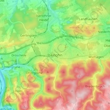
Name: Iserlohn topographic map, elevation, terrain.
Average elevation: 919 ft
Minimum elevation: 420 ft
Maximum elevation: 1,591 ft
Make a donation
Gear up for your next adventure:
As an Amazon Associate, this site earns from qualifying purchases at no extra cost to you.