
Weinheim topographic map
Click on the map to display elevation.
About this map
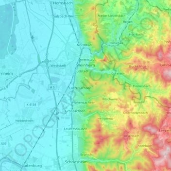
Name: Weinheim topographic map, elevation, terrain.
Location: Weinheim, Rhein-Neckar-Kreis, Baden-Württemberg, 69469, Germany (49.46824 8.60334 49.59384 8.78051)
Average elevation: 650 ft
Minimum elevation: 295 ft
Maximum elevation: 1,752 ft
Other topographic maps
Click on a map to view its topography, its elevation and its terrain.
Sinsheim-Steinsfurt / Insenbach
Germany > Baden-Württemberg > Rhein-Neckar-Kreis > Sinsheim
Average elevation: 669 ft
Gauangelloch
Germany > Baden-Württemberg > Rhein-Neckar-Kreis > Leimen > Gauangelloch
Average elevation: 725 ft
Neckar-Wimmersbach
Germany > Baden-Württemberg > Rhein-Neckar-Kreis > Eberbach
Average elevation: 840 ft