Geolocate

Duff topographic map

Click on the map to display elevation.

About this map

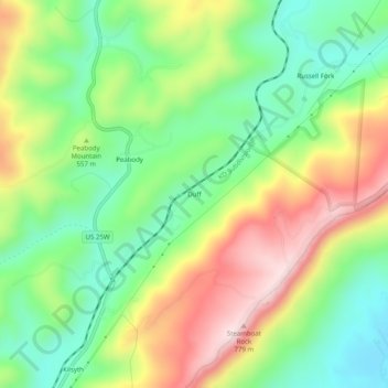
Name: Duff topographic map, elevation, terrain.

Location: Duff, Campbell County, East Tennessee, Tennessee, United States (36.42675 -84.08742 36.46675 -84.04742)

Average elevation: 1,729 ft

Minimum elevation: 1,155 ft

Maximum elevation: 2,562 ft

Campbell County trails, hiking, mountain biking, running and outdoor activities

Other topographic maps

Click on a map to view its topography, its elevation and its terrain.

Jellico

United States > Tennessee > Campbell County

Average elevation: 1,276 ft

La Follette

United States > Tennessee > Campbell County

According to the United States Census Bureau, the city has a total area of 4.9 sq mi (12.7 km2), all land. The elevation varies around the city, around 1,050 ft (320 m) in the valley areas to 1,500 ft (460 m) on ridge tops. The average elevation is around 1,150 ft (350 m).

Average elevation: 1,299 ft

Walden Ridge

United States > Tennessee > Campbell County

Average elevation: 1,316 ft

Jacksboro

United States > Tennessee > Campbell County

Average elevation: 1,227 ft

Jellico

United States > Tennessee > Campbell County

Average elevation: 1,276 ft

Jellico

United States > Tennessee > Campbell County

Average elevation: 1,276 ft

La Follette

United States > Tennessee > Campbell County

According to the United States Census Bureau, the city has a total area of 4.9 sq mi (12.7 km2), all land. The elevation varies around the city, around 1,050 ft (320 m) in the valley areas to 1,500 ft (460 m) on ridge tops. The average elevation is around 1,150 ft (350 m).

Average elevation: 1,299 ft

Jellico

United States > Tennessee > Campbell County

Average elevation: 1,276 ft

Caryville

United States > Tennessee > Campbell County

Average elevation: 1,690 ft

Gear up for your next adventure:

🛰️Handheld GPS Units - Professional satellite navigators for precise backcountry mapping
🛡️Bear Spray Outdoor - Protection in bear country hikes
🪶Camping Sleeping Pad - Comfortable sleeping pad for backpacking
🏫Relief Map Kits - Hands-on tools for teaching landforms and elevation
GPS Sports Watch - GPS watch for running, hiking and training

As an Amazon Associate, this site earns from qualifying purchases at no extra cost to you.