
Make a donation
Gear up for your next adventure:
As an Amazon Associate, this site earns from qualifying purchases at no extra cost to you.
Reit River topographic map
Click on the map to display elevation.
Make a donation
Gear up for your next adventure:
As an Amazon Associate, this site earns from qualifying purchases at no extra cost to you.
About this map
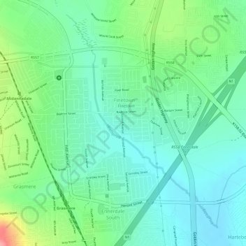
Name: Reit River topographic map, elevation, terrain.
Average elevation: 5,259 ft
Minimum elevation: 5,151 ft
Maximum elevation: 5,502 ft
Make a donation
Gear up for your next adventure:
As an Amazon Associate, this site earns from qualifying purchases at no extra cost to you.
Other topographic maps
Click on a map to view its topography, its elevation and its terrain.
Diepsloot
South Africa > Gauteng > City of Johannesburg Metropolitan Municipality > Diepsloot
Average elevation: 4,616 ft
Johannesburg Ward 88
South Africa > Gauteng > City of Johannesburg Metropolitan Municipality
Average elevation: 5,390 ft
Johannesburg Ward 69
South Africa > Gauteng > City of Johannesburg Metropolitan Municipality
Average elevation: 5,627 ft
Johannesburg Ward 68
South Africa > Gauteng > City of Johannesburg Metropolitan Municipality
Average elevation: 5,561 ft
Make a donation
Gear up for your next adventure:
As an Amazon Associate, this site earns from qualifying purchases at no extra cost to you.
Melville Koppies East
South Africa > Gauteng > City of Johannesburg Metropolitan Municipality > Johannesburg
Average elevation: 5,476 ft
Johannesburg Ward 89
South Africa > Gauteng > City of Johannesburg Metropolitan Municipality
Average elevation: 5,371 ft
Johannesburg Ward 58
South Africa > Gauteng > City of Johannesburg Metropolitan Municipality
Average elevation: 5,659 ft
Rose Gardens
South Africa > Gauteng > City of Johannesburg Metropolitan Municipality > Johannesburg
Average elevation: 5,292 ft
Make a donation
Gear up for your next adventure:
As an Amazon Associate, this site earns from qualifying purchases at no extra cost to you.