
Thank you for supporting this site ❤️
Make a donation
Make a donation
Gear up for your next adventure:
As an Amazon Associate, this site earns from qualifying purchases at no extra cost to you.
Taşoluk topographic map
Click on the map to display elevation.
Thank you for supporting this site ❤️
Make a donation
Make a donation
Gear up for your next adventure:
As an Amazon Associate, this site earns from qualifying purchases at no extra cost to you.
About this map
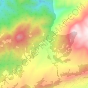
Name: Taşoluk topographic map, elevation, terrain.
Location: Taşoluk, Geyve, Sakarya, Marmara Region, Turkey (40.40170 30.12753 40.44170 30.16753)
Average elevation: 1,916 ft
Minimum elevation: 620 ft
Maximum elevation: 3,018 ft
Thank you for supporting this site ❤️
Make a donation
Make a donation
Gear up for your next adventure:
As an Amazon Associate, this site earns from qualifying purchases at no extra cost to you.