Geolocate

Zwolle topographic map

Click on the map to display elevation.

About this map

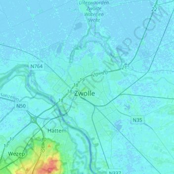
Name: Zwolle topographic map, elevation, terrain.

Location: Zwolle, Overijssel, Netherlands (52.44053 6.00362 52.58794 6.21081)

Average elevation: 10 ft

Minimum elevation: -16 ft

Maximum elevation: 174 ft

Other topographic maps

Click on a map to view its topography, its elevation and its terrain.

Lemelerberg

Netherlands > Overijssel > Lemele

Average elevation: 62 ft

Enschede

Netherlands > Overijssel > Enschede

Average elevation: 112 ft

Zuurberg

Netherlands > Overijssel > Holten

Average elevation: 56 ft

Frankhuis

Netherlands > Overijssel > Zwolle

Average elevation: 10 ft

Witteberg

Netherlands > Overijssel

Average elevation: 187 ft

Tankenberg

Netherlands > Overijssel > de Lutte

Average elevation: 190 ft

Usselo

Netherlands > Overijssel > Enschede

Average elevation: 102 ft

Helhuizen

Netherlands > Overijssel > Holten

Average elevation: 66 ft

Gear up for your next adventure:

📷Action Cameras - Rugged cameras to document your journeys across rugged terrain
🛡️Insect Repellent - Protection against bugs during outdoor activities
🔥Camping Stove - Portable stove for camping and backcountry cooking
🦺Reflective Outdoor Gear - Safety gear for low‑light conditions
🛌Ultralight Sleeping Bags - Compact down bags for cold nights in the wilderness

As an Amazon Associate, this site earns from qualifying purchases at no extra cost to you.