
Thank you for supporting this site ❤️
Make a donation
Make a donation
Gear up for your next adventure:
As an Amazon Associate, this site earns from qualifying purchases at no extra cost to you.
Oeschinensee topographic map
Click on the map to display elevation.
Thank you for supporting this site ❤️
Make a donation
Make a donation
Gear up for your next adventure:
As an Amazon Associate, this site earns from qualifying purchases at no extra cost to you.
About this map
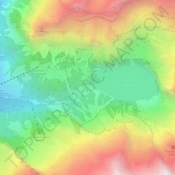
Name: Oeschinensee topographic map, elevation, terrain.
Average elevation: 6,467 ft
Minimum elevation: 3,996 ft
Maximum elevation: 9,764 ft
Thank you for supporting this site ❤️
Make a donation
Make a donation
Gear up for your next adventure:
As an Amazon Associate, this site earns from qualifying purchases at no extra cost to you.
Other topographic maps
Click on a map to view its topography, its elevation and its terrain.
Lac d'Oeschinen
Suisse > Berne > Arrondissement administratif de Frutigen-Bas-Simmental > Kandersteg
Average elevation: 6,293 ft
Altelshütte
Suisse > Berne > Arrondissement administratif de Frutigen-Bas-Simmental > Kandersteg
Average elevation: 6,286 ft