
Make a donation
Gear up for your next adventure:
As an Amazon Associate, this site earns from qualifying purchases at no extra cost to you.
Steibis topographic map
Click on the map to display elevation.
Make a donation
Gear up for your next adventure:
As an Amazon Associate, this site earns from qualifying purchases at no extra cost to you.
Steibis
Steibis (allgäuerisch Schteibing) ist ein Ortsteil in der Gemarkung Aach im Allgäu des Marktes Oberstaufen im bayerisch-schwäbischen Landkreis Oberallgäu. Es liegt auf einer leicht abfallenden Hochebene zwischen dem nördlichen Weissachtal und der südlich liegenden Hochgratkette auf einer Höhe von 860 m. Hausberge sind der Hochgrat und der direkt im Ort fußende Imberg.
Make a donation
Gear up for your next adventure:
As an Amazon Associate, this site earns from qualifying purchases at no extra cost to you.
About this map
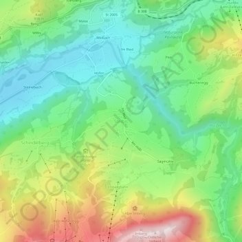
Name: Steibis topographic map, elevation, terrain.
Average elevation: 2,867 ft
Minimum elevation: 2,093 ft
Maximum elevation: 4,278 ft
Make a donation
Gear up for your next adventure:
As an Amazon Associate, this site earns from qualifying purchases at no extra cost to you.