
Make a donation
Gear up for your next adventure:
As an Amazon Associate, this site earns from qualifying purchases at no extra cost to you.
Les Varcins topographic map
Click on the map to display elevation.
Make a donation
Gear up for your next adventure:
As an Amazon Associate, this site earns from qualifying purchases at no extra cost to you.
About this map
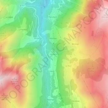
Name: Les Varcins topographic map, elevation, terrain.
Average elevation: 4,908 ft
Minimum elevation: 2,989 ft
Maximum elevation: 6,988 ft
Make a donation
Gear up for your next adventure:
As an Amazon Associate, this site earns from qualifying purchases at no extra cost to you.
Other topographic maps
Click on a map to view its topography, its elevation and its terrain.
Lac Crintallia
France > Auvergne-Rhône-Alpes > Savoie > Saint-Martin-de-Belleville
Average elevation: 7,638 ft
Glacier de Péclet
France > Auvergne-Rhône-Alpes > Savoie > Saint-Martin-de-Belleville
Average elevation: 9,829 ft
Glacier de Thorens
France > Auvergne-Rhône-Alpes > Savoie > Saint-Martin-de-Belleville
Average elevation: 9,797 ft
Lac du Lou
France > Auvergne-Rhône-Alpes > Savoie > Saint-Martin-de-Belleville
Average elevation: 7,513 ft
Make a donation
Gear up for your next adventure:
As an Amazon Associate, this site earns from qualifying purchases at no extra cost to you.