Geolocate

Aliano topographic map

Click on the map to display elevation.

About this map

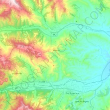
Name: Aliano topographic map, elevation, terrain.

Location: Aliano, Matera, Basilicata, Italy (40.26597 16.17053 40.34503 16.35301)

Average elevation: 1,302 ft

Minimum elevation: 558 ft

Maximum elevation: 3,087 ft

Gear up for your next adventure:

🗺️Topographic Maps - Detailed topo maps for hiking, exploring and outdoor navigation
🛰️Handheld GPS Units - Professional satellite navigators for precise backcountry mapping
Solar GPS Watches - Advanced multisport watches with built-in topographic maps
🩹Survival Bandages - High‑quality bandages for emergencies
🧤Hiking Gloves - Protective gloves for rugged trails

As an Amazon Associate, this site earns from qualifying purchases at no extra cost to you.