
Strietwald topographic map
Interactive map
Click on the map to display elevation.
About this map
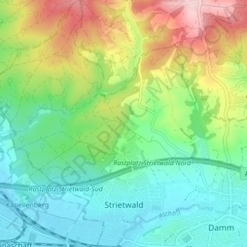
Name: Strietwald topographic map, elevation, terrain.
Location: Strietwald, Aschaffenburg, Bayern, Deutschland (49.98173 9.08025 50.02128 9.12430)
Average elevation: 623 ft
Minimum elevation: 374 ft
Maximum elevation: 1,132 ft
Other topographic maps
Click on a map to view its topography, its elevation and its terrain.
Stadtmitte
Deutschland > Bayern > Aschaffenburg
Stadtmitte, Aschaffenburg, Unterfranken, Bayern, Deutschland
Average elevation: 584 ft