
Stadtmitte topographic map
Interactive map
Click on the map to display elevation.
About this map
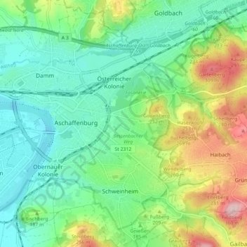
Name: Stadtmitte topographic map, elevation, terrain.
Location: Stadtmitte, Aschaffenburg, Unterfranken, Bayern, Deutschland (49.96028 9.10703 49.98731 9.19455)
Average elevation: 584 ft
Minimum elevation: 341 ft
Maximum elevation: 1,132 ft
Other topographic maps
Click on a map to view its topography, its elevation and its terrain.
Strietwald
Deutschland > Bayern > Aschaffenburg
Strietwald, Aschaffenburg, Bayern, Deutschland
Average elevation: 623 ft