
Thank you for supporting this site ❤️
Make a donation
Make a donation
Gear up for your next adventure:
As an Amazon Associate, this site earns from qualifying purchases at no extra cost to you.
Hochvogel topographic map
Click on the map to display elevation.
Thank you for supporting this site ❤️
Make a donation
Make a donation
Gear up for your next adventure:
As an Amazon Associate, this site earns from qualifying purchases at no extra cost to you.
About this map
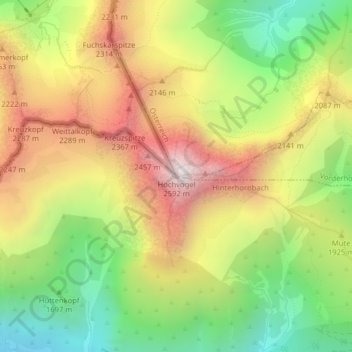
Name: Hochvogel topographic map, elevation, terrain.
Location: Hochvogel, Hinterhornbach, Bezirk Reutte, Tyrol, 6646, Austria (47.38031 10.43671 47.38041 10.43681)
Average elevation: 6,224 ft
Minimum elevation: 4,222 ft
Maximum elevation: 8,412 ft
Thank you for supporting this site ❤️
Make a donation
Make a donation
Gear up for your next adventure:
As an Amazon Associate, this site earns from qualifying purchases at no extra cost to you.