Geolocate

Pandi topographic map

Click on the map to display elevation.

About this map

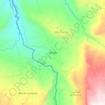
Name: Pandi topographic map, elevation, terrain.

Location: Pandi, Sumapaz, Cundinamarca, Colombia (4.15225 -74.52601 4.23225 -74.44601)

Average elevation: 3,737 ft

Minimum elevation: 1,713 ft

Maximum elevation: 7,073 ft

Gear up for your next adventure:

🪓Survival Multi‑Tool - Versatile tool for camp and trail tasks
🧭GPS Watch Accessories - Bands and chargers for GPS watches
🧥Men's Rain Shells - Premium waterproof and breathable jackets for mountain weather
📦Dry Bags Set - Waterproof storage for electronics and clothes
📚Navigation Handbooks - Master the art of reading topographic maps and using a compass

As an Amazon Associate, this site earns from qualifying purchases at no extra cost to you.