Geolocate

Kollur topographic map

Click on the map to display elevation.

About this map

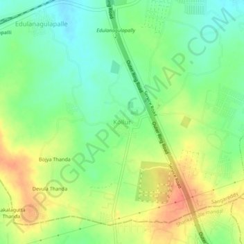
Name: Kollur topographic map, elevation, terrain.

Location: Kollur, Ramachandrapuram mandal, Sangareddy, Telangana, India (17.42446 78.23155 17.46446 78.27155)

Average elevation: 1,873 ft

Minimum elevation: 1,804 ft

Maximum elevation: 1,955 ft

Gear up for your next adventure:

📦Dry Bags Set - Waterproof storage for electronics and clothes
🎒Trail Energy Bars - High‑calorie bars for hiking energy
📦Gear Storage Bags - Organize and protect outdoor equipment
📷Action Camera - Capture your outdoor adventures in HD
🚪Portable Camp Chair - Foldable chair for comfort at camp

As an Amazon Associate, this site earns from qualifying purchases at no extra cost to you.