Geolocate

Valavoor topographic map

Click on the map to display elevation.

About this map

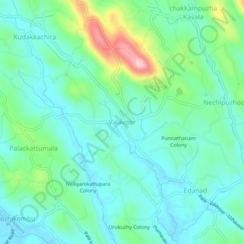
Name: Valavoor topographic map, elevation, terrain.

Location: Valavoor, Meenachil, Kottayam, Kerala, 686635, India (9.72926 76.62404 9.76926 76.66404)

Average elevation: 207 ft

Minimum elevation: 43 ft

Maximum elevation: 722 ft

Other topographic maps

Click on a map to view its topography, its elevation and its terrain.

Melukavu

India > Kerala > Meenachil > Melukavumattom

Average elevation: 1,965 ft

Poonjar-Thekkekara

India > Kerala > Meenachil > Vazhikadavu

Average elevation: 1,234 ft

Chovoor

India > Kerala > Meenachil

Average elevation: 1,073 ft

Gear up for your next adventure:

🗺️NatGeo Topo Maps - High-quality waterproof printed topographic maps of US Parks
🥘Titanium Cookware - Durable, featherlight pots and pans for backpacking
📻Weather Alert Radios - Stay informed of storm risks while off-the-grid
🧢Outdoor Hiking Hat - Sun protection hat for outdoor explorers
🪶Camping Sleeping Pad - Comfortable sleeping pad for backpacking

As an Amazon Associate, this site earns from qualifying purchases at no extra cost to you.