
Thank you for supporting this site ❤️
Make a donation
Make a donation
Gear up for your next adventure:
As an Amazon Associate, this site earns from qualifying purchases at no extra cost to you.
Villavicencio topographic map
Click on the map to display elevation.
Thank you for supporting this site ❤️
Make a donation
Make a donation
Gear up for your next adventure:
As an Amazon Associate, this site earns from qualifying purchases at no extra cost to you.
About this map
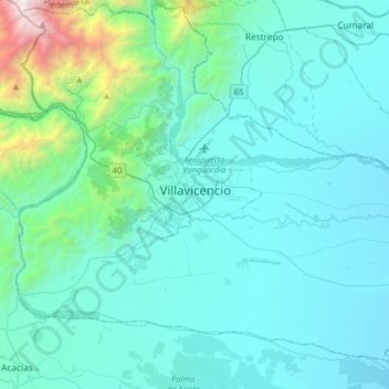
Name: Villavicencio topographic map, elevation, terrain.
Location: Villavicencio, Capital, Meta, 500002, Colombia (3.97151 -73.78067 4.29151 -73.46067)
Average elevation: 2,205 ft
Minimum elevation: 981 ft
Maximum elevation: 12,064 ft
Thank you for supporting this site ❤️
Make a donation
Make a donation
Gear up for your next adventure:
As an Amazon Associate, this site earns from qualifying purchases at no extra cost to you.