
Make a donation
Gear up for your next adventure:
As an Amazon Associate, this site earns from qualifying purchases at no extra cost to you.
Margraten topographic map
Click on the map to display elevation.
Make a donation
Gear up for your next adventure:
As an Amazon Associate, this site earns from qualifying purchases at no extra cost to you.
Margraten
Margraten had van 1925 tot 1938 een halte aan de tramlijn Maastricht - Vaals, die ter hoogte van Margraten langs de Rijksweg (de N598) liep. Bij de kruising met de Rijksweg bevond zich een diepe gleuf die voor de tramlijn uitgegraven was. Aan de oostkant van Margraten week de stoomtram naar het zuiden af om langzaam in een gegraven tracé steeds verder te dalen om in het Gulpdal uit te komen. De eerstvolgende haltes lagen in het westen bij Cadier en Keer (Zwarteweg-Keunestraat) en in het oosten ten noordwesten van Euverem aan de weg naar Reijmerstok.
Make a donation
Gear up for your next adventure:
As an Amazon Associate, this site earns from qualifying purchases at no extra cost to you.
About this map
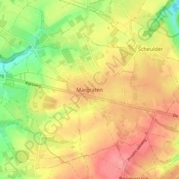
Name: Margraten topographic map, elevation, terrain.
Average elevation: 522 ft
Minimum elevation: 367 ft
Maximum elevation: 636 ft
Make a donation
Gear up for your next adventure:
As an Amazon Associate, this site earns from qualifying purchases at no extra cost to you.