
Thank you for supporting this site ❤️
Make a donation
Make a donation
Gear up for your next adventure:
As an Amazon Associate, this site earns from qualifying purchases at no extra cost to you.
Terroso topographic map
Click on the map to display elevation.
Thank you for supporting this site ❤️
Make a donation
Make a donation
Gear up for your next adventure:
As an Amazon Associate, this site earns from qualifying purchases at no extra cost to you.
About this map
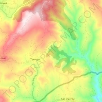
Name: Terroso topographic map, elevation, terrain.
Location: Terroso, Vilardevós, Verín, Orense, Galicia, España (41.85208 -7.30484 41.90900 -7.24322)
Average elevation: 2,602 ft
Minimum elevation: 1,673 ft
Maximum elevation: 3,478 ft
Thank you for supporting this site ❤️
Make a donation
Make a donation
Gear up for your next adventure:
As an Amazon Associate, this site earns from qualifying purchases at no extra cost to you.