
Addlestone topographic map
Click on the map to display elevation.
Addlestone
Elevations range between 11 metres (36 ft) and 40 metres (130 ft). The maximum is on Row Hill recreation ground, Row Town, Addlestone; a ridge that continues to the northwest of Row Town where it is known as Ongar/Spinney Hill, where Great Grove Farm in its centre also reaches this height; the minimum is by the Thames and along the Woburn Park Stream which is the main distributary of The Bourne the main waterway of the village, a stream rising as the Windle Brook in Windlesham cutting a shallow ravine, flowing past the McLaren Technology Centre and Woodham then passing to the east of the village.
About this map
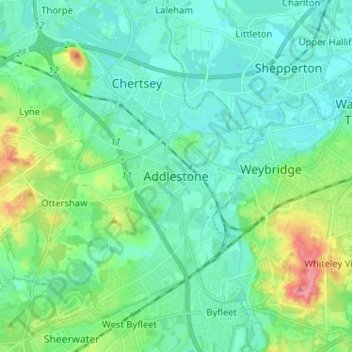
Name: Addlestone topographic map, elevation, terrain.
Average elevation: 79 ft
Minimum elevation: 23 ft
Maximum elevation: 269 ft