
Make a donation
Gear up for your next adventure:
As an Amazon Associate, this site earns from qualifying purchases at no extra cost to you.
Gözne topographic map
Click on the map to display elevation.
Make a donation
Gear up for your next adventure:
As an Amazon Associate, this site earns from qualifying purchases at no extra cost to you.
Gözne
Gözne is 28 kilometres (17 mi) north of Mersin. It is situated in the southern slopes of the Taurus Mountains. The average altitude is 1,045 metres (3,428 ft). In some locations of the town, both Mersin and the Mediterranean Sea can be viewed. The road between Mersin and Gözne is quite well cared and accessible whole year, the average travel time being about 30 minutes.
Make a donation
Gear up for your next adventure:
As an Amazon Associate, this site earns from qualifying purchases at no extra cost to you.
About this map
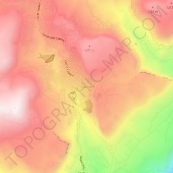
Name: Gözne topographic map, elevation, terrain.
Location: Gözne, Toroslar, Mersin, Mediterranean Region, Turkey (36.97781 34.55355 37.01781 34.59355)
Average elevation: 3,553 ft
Minimum elevation: 1,637 ft
Maximum elevation: 4,557 ft
Make a donation
Gear up for your next adventure:
As an Amazon Associate, this site earns from qualifying purchases at no extra cost to you.