Geolocate

Egypt topographic map

Click on the map to display elevation.

About this map

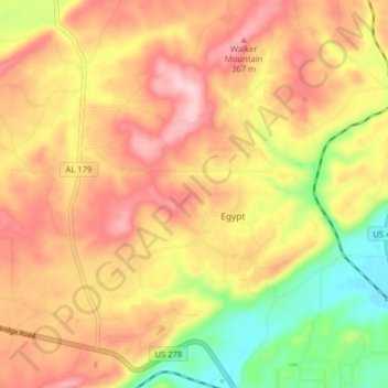
Name: Egypt topographic map, elevation, terrain.

Location: Egypt, Etowah County, Alabama, United States (34.04441 -86.18927 34.11049 -86.13291)

Average elevation: 938 ft

Minimum elevation: 548 ft

Maximum elevation: 1,237 ft

Etowah County trails, hiking, mountain biking, running and outdoor activities

Gear up for your next adventure:

🪶Fire Starter Kit - Reliable fire starter for survival and camping
🔥Camping Stove - Portable stove for camping and backcountry cooking
🌲Outdoor Survival Books - Best books on survival skills
🧭Orienteering Set - Complete compass and map reading kit
🎒Trail Energy Bars - High‑calorie bars for hiking energy

As an Amazon Associate, this site earns from qualifying purchases at no extra cost to you.