
Hancock topographic map
Click on the map to display elevation.
Hancock
Hancock is located in eastern Addison County, extending from the crest of the Green Mountains in the west to the valley of the White River in the east. The village of Hancock lies along the White River at the confluence of the Hancock Branch from Middlebury Gap. Vermont Route 100 leads north-south through the town, following the White River, leading north into Granville and Warren, and south into Rochester and Stockbridge. Vermont Route 125 leaves Route 100 in Hancock village and leads west, across Middlebury Gap (elevation 2,144 ft or 653 m) into Ripton and Middlebury. The Middlebury College Snow Bowl, a downhill ski area, is on the western side of Middlebury Gap. The Long Trail follows the crest of the Green Mountains in the western part of Hancock, crossing the summit of Worth Mountain (3,234 ft or 986 m) and reaching the summit of Boyce Mountain (3,323 ft or 1,013 m) a few feet north of the town boundary in Ripton. Texas Falls is a scenic waterfall on Hancock Branch that can be reached by road and has a Green Mountain National Forest recreation area nearby.
About this map
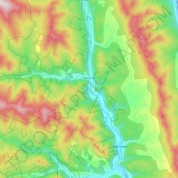
Name: Hancock topographic map, elevation, terrain.
Location: Hancock, Addison County, Vermont, 05748, United States (43.86165 -73.00164 43.97420 -72.81633)
Average elevation: 1,768 ft
Minimum elevation: 781 ft
Maximum elevation: 3,363 ft
Addison County trails, hiking, mountain biking, running and outdoor activities
Other topographic maps
Click on a map to view its topography, its elevation and its terrain.
Abbey Pond Cascades (lower)
United States > Vermont > Addison County > Middlebury
Average elevation: 1,001 ft
Kingsland Bay
United States > Vermont > Addison County > Ferrisburgh > Ecole Champlain
Average elevation: 105 ft
Lake Dunmore
United States > Vermont > Addison County > Salisbury > Lake Dunmore
Average elevation: 630 ft